Thursday, October 17, 2013

The Galapagos - The Most Amazing Place on Earth

Clambering over the bow of the Zodiac, we were immediately amongst hundreds of sea lions lounging and socializing along the sandy beach. Some were dozing in the sun. Little pups suckled their mothers. Others waddled into and out of the sea. The sea lions were indifferent to us humans, so we wandered, barefoot, among them, staring wide-eyed and photographing to our hearts’ content. Pelicans and blue-footed boobies patrolled in the sky and every few moments one would transform into a svelte dagger and plunge into the water. A hawk watched from the cliff top.

I was on a tour in the Galapagos Islands, those isolated, arid volcanic islands that sit astride the equator about 1,000 kilometres west of Ecuador. As I was learning, these islands are home to the most remarkable displays of nature on this planet.
At one end of the beach, we saw what appeared to be a confrontation. A pelican stood atop a great rock, like the king of the castle. Its long beak pointed diagonally downward at a black marine iguana only two feet away that appeared to be climbing to conquer the top. Dozens of bright red and black Sally Lightfoot crabs were scattered on the rock like spectators, a few small ones even riding on the iguana, which was about 3-feet long and looked like it had come directly from the Paleozoic era. It was an unusual and beautiful tableau.  I was excited!

We proceeded to walk around the island, barren, dusty and dotted with large cacti. But where the land met the water, life thrived. The most bizarre were large groups of the prehistoric-looking marine iguanas. They lounged lazily together, often flopped right on top of each other. The guide explained that they swim and seek food in the sea and then later, back on land, blow saltwater out their nostrils.

Too soon the tour ended, and we motored back to the Galapagos Legend, a 100-passenger cruise ship, where we lived in comfort. Over four wonderful days, we did three tours daily.
Each tour was fabulous, with one incredible surprise following another. We saw 150-year-old, lumbering tortoises, one with a black cowbird sitting placidly aboard its shell. We strolled amongst a colony of blue-foot boobies and watched intricate courtship dances. In the frigate-bird nesting area, males puffed out large bright-red balloons under their chins, striving to impress females. At a lake, elegant flamingos walked, seeking food under the shallow water. We saw yellow warblers and, of course, the ordinary-looking finches, whose beaks helped Charles Darwin decipher the processes of evolution.

When snorkeling, I marveled at schools of colourful fish and at large turtles, who swam underwater like ballet dancers. A young sea lion swam just below and turned upside down to get a better view of me. Occasionally a shark would glide past like a stealth bomber, causing my heart to momentarily stop beating.

Every night we would recount the astonishing sights we had seen — as Darwin and his companions must have — while watching the blazing sun drop into the sea.

If You Go, You Gotta Know
Galapagos Info: www.galapagosislands.com/


Monday, October 14, 2013

High on Quito

My heart pounded as I clutched a rickety metal railing precariously attached to the outside of the south tower high atop the Basilica del Voto Nacional in Quito. After scaling numerous spiraling staircases, I was nearing the end. Just this vertigo-inducing ladder left to climb. Puffing in the thin air (elevation 9,300 feet) and under a piercing sun, I felt like Hilary scaling Everest.

Reaching the pinnacle, I gasped in delight, for Quito, the capital of equator-straddling Ecuador, was spread out before me like a feast. Reddish, tile-covered roofs stretched in a north-south direction, framed by the Andes and the mighty volcano, Pichincha. To the south, the statue of the Virgin stood atop Panicello Hill with her wings outstretched as though blessing the city.

I located the cathedral domes that mark the city’s historic center, which dates to the 16th-century Spanish colonial times and was the first place to be selected as a UN World Heritage Site. I could just make out the palm-fringed Plaza Grande where yesterday I had strolled. I had visited the nearby grand buildings including the Presidential Palace with a pair of colourful, pike-bearing soldiers guarding the entrance. I had sat in the baroque La Compañia de Jesús church, considered to be the most beautiful in Latin America, marveling at the nine tons of gold-leaf covering the ornate carvings. At cobble-stoned Plaza San Francisco, I bumped into a friendly mime before visiting the imposing monastery.

Although the cathedrals, plazas and streets arrayed below couldn’t speak, I imagined the history they have seen. Yesterday at lunch in the elegant Patio Andaluz hotel, a colonial, 470-year-old building, our guide had described some of Ecuador’s past. “Our country was shaped by the Spanish conquistadores. More recently, we’ve had a continuous parade of presidents, several of whom were killed, one by machetes,” he said. “Can you imagine, only three years ago President Correa was held hostage and had to be rescued by force.” I was impressed by his accounts. History in Canada is dusty and archaic. Here it is alive and happening.

My eyes roved over the many parks and plazas I had explored earlier. I could see roads, like thin spider-webs, where buskers entertained at busy intersections, one red light at a time, by juggling, swallowing knives and riding unicycles. Yesterday, we had traveled one of those road northward to La Mitad del Mundo, the center of the world, which lies right on the equator and I stood astride that important imaginary line. Everywhere we had encountered Latin friendliness.

Looking around, I was not surprised that Quito was selected as South America’s Leading Destination at this year’s World Travel Awards (breaking Rio de Janeiro’s ten-year reign).

Although not visible, villages lay over the horizon. Otavalo offers markets overflowing with handicrafts. Hundreds of species of hummingbirds live in the cloud forest at Mindo. Thermal baths and grand views of snow-capped volcanoes await at Papallacta.

A gentle breeze moaned in the high tower, beckoning me to descend, and explore the city and region.

If You go
Quito Info: www.quito.com.ec/en/
Stay & Dine: www.hotelpatioandaluz.com


Wednesday, October 9, 2013

Completing the Circle of Estonia (Part 3 of 3)


The sun sparkled as we drove south from Võru and up a gentle slope to Big Egg Mountain, the highest point in Estonia and, well, more like a subdued hill. From the top we looked upon a rolling landscape of forest with patches of farmland.

At our next stop, the Võru Museum, we were the only visitors, a reminder of how peaceful the tourist path is away from Tallinn. The museum was grim, mostly about wars. I was drawn to a bunker where the Forest Brothers lived while they fought guerrilla 

warfare against the Russians following World War II.

We often visited cemeteries to enjoy the greenery and listen to the stories the stones tell. At Elva, I visited the graves of my maternal grandparents wishing we had gotten to know each other.

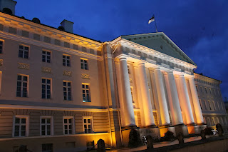
Then we were in Tartu (population 105,000) and could feel the vibrancy of a university city. We set off on a walking tour. At the main square, a regal town hall loomed over a cobble-stoned square lined by outdoor cafes. Statues proliferated and we particularly enjoyed the bronze Oscar Wilde and Eduard Vilde casually chatting. Then we were on Tartu University (established 1632) campus, which is heavily treed. Especially impressive was the History Museum located in the majestic ruins of a cathedral dating to the 13th century. Then we came upon the main university building with its dominating six tall Doric columns. Soon we were in 14th century St. John’s Church with its almost 1000 terra cotta figurines. An orchestra was rehearsing, a reminder that Estonians love music and that the peaceful Singing Revolution helped the country gain its freedom.

After two wonderful days we departed Tartu. At a tiny village we bumped aboard an old one-car barge and were hand-winched across the Ema River. Estonia is a delightful mixture of old and new!

Driving north along the shore of Peipsi Lake, we passed through small villages where old ladies sold onions and smoked fish by the roadside.

We arrived in Narva (95% Russian population) under dark ominous skies. The border crossing to Russia had long line-ups and menacing barbed wire. Narva castle is well preserved and, surprise, only a short cannon-shot across Narva River in Russia is the almost identical Ivanogrod Fortress.


I photographed Lenin’s statue in an out-of-the-way corner of the castle grounds and learned that strong Russian pressure had prevented its consignment to the scrap heap after independence. The large Russian population in Estonia (25%) is certainly awkward. We were happy to head westward.

In Rakvere, the Aqva Spa Hotel included an extensive indoor water park, saunas, a spa and lap-pools, which were packed. I entered the sauna, where I sweated in the semi-dark, enjoying Estonian voices and the slapping of birch twigs against skin. In the morning we visited Rakvere Castle and then drove westward.

Estonia is dotted with hundreds of manor houses, but none is finer than the baroque Palmse Manor in Lahemaa National Park. We wandered around its extensive, immaculate gardens, marvelling at the rich elegance, a contrast to the surrounding rural area.

A short drive took us to pretty Käsmu on the Gulf of Finland, which has many trendy summer homes. I walked along the shore, thinking of my mother who escaped, pregnant with me, from a cold shore like this in a crowded small boat as the Russians invaded.

That evening, I nursed a dark beer in Tallinn. I had learned that Estonia is about history and people. It was heart-warming to meet relatives, and satisfying to see Estonia blossoming after 50 years of repression. I regretted not having visited earlier.


If You Go
Aqva Spa Hotel, Rakvere:  www.aqvahotels.ee/en
Hotel London, Tartu:  www.londonhotel.ee/en
General information: www.visitestonia.com/en/
Impressions of Estonia, useful book with 124 photos:

 www.blurb.ca/bookstore/detail/3850029

Wednesday, October 2, 2013

Circling Estonia (Part 2 of 3)

We left Tallinn and headed southwest toward Pärnu, the start of our counter-clockwise trip around Estonia. We drove from one historic spot to another following the ubiquitous brown signs pointing to historic/cultural sites. Thanks (or curses) to its strategic location, Estonia has long been fought over and, thus, has an enormous number of castles, fortifications and other ruins.

Our first stop was Padise Monastary, whose construction began in the 13th century. It had a vaulted church and was fortified, but had fallen into ruins. There was no entrance fee and a large sign provided a detailed history.

We meandered along back roads. There was little traffic, the signage was good and there were virtually no billboards nor litter. It was peaceful and restful.

The steepled church at a small village beckoned. The cemetery was beautiful. A monument to more than 100 people massacred by the Russians gave an insight into the sad decades of oppression that Estonia suffered.

With “Agnes” (our Estonian-speaking GPS) giving directions, we drove through a flat landscape with birch forests, wetlands and occasional farms and villages.

We arrived at Pärnu, a popular sea-side resort with a long sandy beach, many parks and a rich cultural life. However, at the end of September a cool wind blew along empty streets. The town centre featured a walking promenade and, delightfully, no big chain stores. At a small, back-alley restaurant, we enjoyed a cheap, tasty meal while a chess game was contested at the next table.

Next morning the breakfast table was elegantly adorned with a fresh rose and candles in pewter holders. Omelettes were followed by Estonia crepes — one of my childhood favourites!

We drove leisurely toward Saaremaa, Estonia’s largest island. The ferry was cheaper, more efficient and more comfortable than those plying Canada’s west coast.

We wandered around Koguva village, a national heritage fishing village with moss-covered stone fences, log buildings and thatched roofs. My camera clicked constantly.

The highlight of Kuresaare, Saaremaa’s capital, was the castle, the best-preserved medieval (14th century) stronghold in the Baltics. A small exhibit dedicated to the Estonians murdered by the Soviets in 1941, brought tears to our eyes.

Next morning, we headed toward Võru, passing wooden houses and remnants of the Soviet-occupation days: deteriorating apartment blocks and large abandoned collective-farm buildings. A small detour led us to Karski Fortress (1248) along with its pretty Baroque church. Wildflowers bloomed alongside the ruins.

Motoring eastward, the countryside became rolling and more forested. We popped into Valka, Latvia. There was no border stop, just a sign. Latvia looked the same as Estonia except the signs and names were incomprehensible.

Nearing Võru, “Agnes” led us to the farm of my cousin, Matti, whom I had never met. His family greeted us with open arms and sat us down to a hearty farm meal. They spoke no English but we managed quite nicely, aided by a few glasses of Vana Tallinn, a liquor they explained was more valuable than money during the occupation. Then we visited the neighbouring farm, now abandoned, where my father grew up. I was moved.

Finally we arrived at the Kubija Hotel-Naturespa, south of Võru where roller-bladers and runners raced along forest trails. Erki Nool, the legendary gold-medallist in the decathlon at the 2000 Olympics, trained here and the lobby boasts a statue of him pole-vaulting.

If You Go
- Villa Wesset Hotel, Parnu:  www.wesset.ee
- Kubija Hotel-Naturespa, Võru:   www.visitestonia.com/en/kubija-hotel-nature-spa
- General information: http://www.visitestonia.com/en/
- Impressions of Estonia, useful book with 124 photos: www.blurb.ca/bookstore/detail/3850029

Connecting with My Roots in Estonia (Part 1 of 3)

Although I’d never been to the homeland, I grew up speaking Estonian. But I was always reticent to visit my homeland. Finally, I decided to go.

Entering the medieval Old Town, I was overwhelmed with emotion for Tallinn is one of Europe’s most beautiful capitals with narrow cobblestone streets, church spires, medieval buildings, thick battlements and towers.

Over the next two days my dearest, Allyson, and I
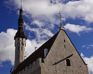
walked and walked, immersing ourselves in the glorious Old Town, which was established in 1219 by the Danes. The town is surprisingly well preserved given the wars that Estonia has suffered. At the centre is the town hall square, which is dominated by a Gothic town hall (1404) and lined with bustling open-air cafes. Patio umbrellas carried the name Saku (the local beer). Throngs of tourists milled in the square for Tallinn is a regular stop for cruise ships.

The Old Town, a UNESCO World Heritage Site, is actually two towns, each with its own fortifications. The upper one was for nobles and the lower town for merchants. About 2 kilometres of sturdy stone walls and 27 towers are still preserved.

The ramparts of upper Town offer wonderful views onto the rooftops and spires of lower Town. We visited the parliament buildings, the Russian Orthodox Alexander Nevsky cathedral and Pikk Hermann tower, which reminded me of the Estonian flag holder in my parents’ home long ago.

The lower town is full of museums and churches. I particularly enjoyed the Passage of History where plaques in the sidewalk outline Estonian history from 1154 to the present.

Next day, our guide pointed to a stately Gothic house. “That was the former KGB headquarters,” she said. “This street was the most feared place in the city.” As we were to learn, Russia still casts a dark shadow over the land.

Our local haunt became the Hell Hunt bar, on whose window a smiling wolf carries a naked blonde lady.
The beer was delicious and cheap and Allyson and I usually ordered the house light and dark beers. Restaurants and bars abounded for Tallinn has a raucous night life.

My cousins, who I met for the first time, explained that Estonia is a progressive country and has made huge strides since gaining its freedom in 1991. Skype was invented here; there is almost no government debt; Estonia is a member of NATO and the Eurozone; and voting is conducted via Internet. I was proud.

We visited Seaplane Harbour, a brand-new, must-see maritime museum just outside the Old Town. The main building is an immense dome, originally built in 1917. Inside, it is surreal and contains a submarine, the oldest boat in Estonia and much more.

On the fourth day, we rented a car and set off to circle the country. We were entering terra incognita for tourists rarely venture outside Tallinn.


If You Go
Meriton Old Town Hotel:  www.meritonhotels.com
General information: http://www.visitestonia.com/en/
Impressions of Estonia, useful book with 124 photos:
 www.blurb.ca/bookstore/detail/3850029

Saturday, August 31, 2013

Rolling Round Richmond: The Great Lulu Loop — Post 5 of 5

Next morning, I set off on the third and final day of cycling the Lulu Loop. I started by visiting Village Bikes, who had provided my trusty 18-gear steed. Ray Mystiuk said, “This shop has been a local fixture for four generations. My grandfather started Steveston’s first barber shop here in 1940. Now my son runs the bike shop.”

Ray, who operates Steveston Water Taxi, and I pedalled to the wharf, where we boarded his boat. We puttered along the river, passing Fisherman’s Wharf, an immense tangle of spars and masts. Ray described the vibrant estuary nature including seals, sea lions, blue herons and sea birds. “I do water tours, but at-sea memorial services have become my main business.”

Soon after I was cycling along the riverbank through the Britannia Heritage Shipyard, a National Historic Site, where Steveston’s history is laid out like a delicious buffet. I meandered amongst the restored buildings where boat yards and living quarters once thrived.

I reached London Farm with my stomach growling. Jenny, a delightful lady, showed me the 1880 heritage building and kindly offered me Lady London tea (blended on the farm) with a cranberry scone and a lemon square. I was in heaven, sitting in the cool veranda, enjoying the tea and listening to Jenny describe the farm’s history.

The sun beat down. My wheels rolled along the path. Fishing boats chugged past in the river. Then I came upon Finn Slough, probably the strangest place in Richmond. More than a century ago, Finnish fishermen built houses on stilts in this swampy river branch. Today, about two dozen people live here as squatters in derelict homes, paying no tax and enjoying a hippy-style existence.

Cycling along, I heard the sound of a bongo drum. Soon I was chatting with Raph, a member of the Latin American band, Rumbacalzada. His playing and friendliness inspired me as I pushed on.

A little later I met Morgan who was juggling with three lemons. He was far from joining Cirque de Soleil, but kept trying over and over again.

The path ended and I turned north on No. 5 Road and then east on Steveston Highway. Crossing the overpass at Highway 99 caused some anxious moments, but soon I was at the Holiday Inn Express at Riverport, my refuge for the night. After a luxurious shower I went to explore this area, known as the Entertainment District, which includes a mammoth SilverCity cinema complex, the Six Rinks (yes, with six sheets of ice), a huge Watermania pool, The Zone bowling lanes and a Go Bananas play centre.

Best of all, I found the Big River Brew Pub, where I celebrated the end of the Great Lulu Loop. The bicycle, I decided, is the perfect way to travel. Sipping a Sawmill Alley Brown Ale, I re-lived my adventure, overwhelmed by the amazing range of sites and people I had encountered. I had experienced big city bustle and bucolic rural roads. I had peeked back in history. I had witnessed Richmond’s vast ethnic diversity. The Richmond Oval was grandiose. Life at Finn Slough was simple. I had eaten Asian cuisine, enjoyed tea, feasted on seafood and munched on blackberries.

My butt was sore, but I was one happy guy.


Need to Know
Village Bikes - www.village-bikes.ca
Steveston Water Taxi - www.StevestonWaterTaxi.com
Britannia Heritage Shipyard - www.britannia-hss.ca
London Farm - londonheritagefarm.ca


Friday, August 30, 2013

Rolling Round Richmond: The Great Lulu Loop — Post 4 of 5


I was nearing the end of day two of my grand loop of Lulu Island, aka Richmond. After visiting with Harold Steves, I continued along the dyke path. An information sign described a fort that stood here during World War 2, although no sign of it remained. Surprise! The sign showed an old photo of soldiers saluting Harold Steves, at age seven, dressed up as an officer.

With sweat trickling down my back I reached Garry Point, a peninsula jutting out from the southwest corner of Lulu Island. The park catches sea breezes and is popular with kite enthusiasts. I spoke with a chap flying a model airplane. “She’s difficult to control in these winds,” he said, but he flew the plane beautifully.

I cycled slowly into Steveston alongside beaches dotted with umbrellas and children playing in the water. Every now and again, a dark, rusting fishing boat cruised past in the river.

Steveston is home to the largest commercial fishing fleet in Canada. Fittingly, my first stop was the Gulf of Georgia Cannery, a rambling old building on pilings over the Fraser River. This National Historic Site gave a vivid insight into the times when the Fraser was the richest salmon river in the world and Steveston boasted 17 canneries.

I cycled a few blocks to the Steveston Garden Suite, a luxurious one-bedroom suite. Ravenous, I wolfed down the cheesecake the proprietors had kindly left.

I sought dinner along the boardwalk at Fisherman’s Wharf, which was crowded with smiling tourists. The smell of fish and saltwater hung in the air and fishermen hawked salmon, halibut and prawns direct from their boats. The restaurant tables overflowed with clinking glasses and plates piled with seafood. Selecting a restaurant was a daunting task but I finally climbed the stairs to the Charthouse and nursed a beer as I gazed upon a forest of masts. The lowering sun poured in the windows, and the wild salmon was delicious.

With a full tummy I pedalled onto a pier to watch masts silhouetted against an orange sky. Then I went to Garry Point and watched a glorious sunset, with the horizon turning fiery reds and oranges. Thinking my great Lulu Loop couldn’t possibly get better, I turned around to find a full moon beaming down on me. I slept well with pleasant dreams.


Need to Know
Gulf of Georgia Cannery - gulfofgeorgiacannery.com


Thursday, August 29, 2013

Rolling Round Richmond: The Great Lulu Loop — Post 3 of 5

I was into day two of my grand loop of Lulu Island, aka Richmond. I left the Golden Village and joined the riverside path. What a transformation! This section of the path leading to the Richmond Oval, blessed by federal funding for the 2010 Olympics, is magnificent with large sculptures and playgrounds lining the paved path.

Arriving at the Oval, I was awe-struck for the building is an architectural masterpiece, and of gargantuan proportions. The Oval contains two hockey rinks. A training session for goaltenders had just finished and I was surrounded by young men, who, encased in their goalie pads and masks, looked like giant robots. The Oval also has six basketball courts, dozens of ping pong tables, six badminton courts, a track, volleyball courts, towering climbing walls, an endless row of exercise equipment and more. One of the largest and most magnificent sports facilities in the country, the Oval is a wonderful legacy from the Olympics.

I cycled on. At a viewpoint, I gazed across the river at a small seaplane terminal, with noisy floatplanes landing and taking off on the river. Behind it, enormous jetliners from the Vancouver International Airport were constantly landing or soaring high into the sky.

I pedalled on, enjoying the fresh air and hot sun. As the river widened into a broad delta I made a sweeping turn to the south. Here the path is on the dyke that protects low-lying Richmond from high tides and storm water. I passed picnic tables, wooden benches and other smiling cyclists and then turned into Terra Nova Rural Park. The community gardens have 120 individual plots, each uniquely different, but all overflowing with an abundance of roses, tall sunflowers, and vegetables.

I met Ian Lai, the driving force behind the Richmond Schoolyard Society (KidsintheGarden.org). As he tended to several beehives, he said, “We teach children to appreciate food and how it is grown. I also teach them to slow down and to be mindful of all around them.” I nodded, feeling that more of us should heed his philosophy.

Back in the saddle I headed south on the well-maintained West Dyke Trail under a relentless hot sun. I waved to passing cyclists and sipped frequently from my water bottle. The path ran beside an attractive parkland of driftwood logs and greenery dotted by purple loose strife.

I made a short detour to visit Harold Steves, a long-time Richmond councillor and a font of historic knowledge. He lives on the farm started by his great grandfather, who arrived in Richmond in 1877, and after whom Steveston is named. While showing me his heirloom seeds, he explained that Lulu Island was named after a dance-hall girl. “This was one of the first farms in BC,” he said. “The houses were on stilts because the dyke wasn’t built until 1908.”


Need to Know
Richmond Oval - www.richmondoval.ca


Wednesday, August 28, 2013

Rolling Round Richmond: The Great Lulu Loop — Post 2 of 5

I was touring the perimeter of Lulu Island, aka the City of Richmond, in a counter-clockwise direction and, late in the afternoon of a sun-kissed day, had reached the easternmost point. With a pleasant feeling of fatigue I turned westward along the northern edge of the island. Residences and light industry changed briefly to major roads and big box-stores and then back to residences. I detoured to seek out Paulo`s Pizzeria, the easternmost restaurant in Richmond. Starved, I wolfed down a House Special pizza. Delicious!

Refreshed, I headed toward the sinking sun in a rural landscape along River Road, which was narrow, gently winding and seemed endlessly long to my tired body. A log boom about 600 metres long snaked upriver towed by three tugs. More logs were anchored all along the shoreline.

Much of my enjoyment, I realized, was because I had never cycled these paths and roads before. I felt like an explorer, with a sense of exhilaration, anticipation.

Twice, bike racers, dressed in colourful, sleek garb, flew past making me look like a doddering slowpoke. But I didn’t care; I was enjoying myself immensely. Finally, I entered an urban area, passed under the Knight Street Bridge, cycled along some streets and dismounted at the Accent Inn, which features a Bike Love program, complete with washing and tune-up area.

After a shower and brief rest, I place my weary butt back in the saddle and pedalled to the International Summer Night Market. What a vibrant place! Over 60 vendors offered a wide variety of mostly Asian food including hurricane fries, squid jerky and fish balls. I munched a waffle-on-a-stick while mingling with the happy throngs. A continuous stage show featured local young people hip-hop dancing and singing. Vendors sold crafts, mobile phone covers, jewellery and assorted odds and ends, all at cut-rate prices. As dusk crept over the market, I headed to a well-earned sleep.

Next morning, I gently rubbed my sore behind, mounted up and headed north to rejoin the river-side path. I rolled along watching sleek Canada Line trains cross a bridge, log booms in the river and beautiful purple loosestrife and other wildflowers along the shore. Ah, the lazy dog-days of summer. I briefly joined two young ladies picking the first blackberries of the season. Yumm!

The path ended and I followed streets through an industrial area to the River Rock Casino. I stepped into the main lobby, which towered elegantly over me. Feeling out of place in my scruffy biking gear, I mumbled an apology to a statue of a Chinese man and departed.

I detoured inland a few blocks to explore the Golden Village, an area that feels like the Orient for Richmond has an enormous Chinese population. I entered the Yao Feng shopping centre and the Osaka Supermarket where I was almost the only non-Chinese shopper. The store had a Dim Sum bar and the shelves were stocked with unusual Asian foods. Next I cycled along Alexandra Road with more than 200, mostly Asian, restaurants in a few blocks. Alas, it was too early for lunch.

Need to Know
International Night Market - www.summernightmarket.com
River Rock Casino & Hotel - www.riverrock.com

Tuesday, August 27, 2013

Rolling Round Richmond: The Great Lulu Loop — Post 1 of 5

Afflicted by islomania (an unswerving love of islands), I was delighted to learn the city of Richmond lies primarily on Lulu Island, which is shaped like a whale, swimming west in the delta of the Fraser River. I immediately made plans to bicycle around Lulu’s perimeter, rolling along at my own pace, the wind and sun in my face.

Richmond has much to offer, so I planned a three-day, 85-km counter-clockwise tour of the island. My goal — other than sheer enjoyment — was to see if the circumnavigation of Lulu would make a good stand-alone tour, through which visitors could experience Richmond. The answer is a resounding ‘yes.’ The tour was so action-packed and rewarding that I need five posts to give it proper credit.

I set out on a sun-kissed day from the junction of Steveston Highway and No. 6 Road, on the southern underbelly of the whale. I headed north as the shoreline to the east was blocked. (Hopefully, this will be fixed in the future.) No. 6 Road is delightfully rural. Numerous blueberry stands and U-pick farms tempted me. The air was fresh, with an occasional earthy waft of manure.

I turned east on Westminster Highway, following a paved bike lane, passing cornfields and greenhouses. Soon I rolled into Lulu Winery, where Kathryn led me on a tour and explained that Lulu is BC’s fifth largest winery. Sipping a limited-production Meritage, I concluded Lulu makes darn good wine! After an icewine, their signature wine, I wobbled off.

Within minutes I arrived at an ornate, exotic building, a Sikh temple, the Nanaksar Gurdwara Gurusikh Temple, which seemed to have been transplanted straight from India. Many men wore turbans and many women wore saris. I entered the main worship area, first covering my head with a scarf and removing my shoes. Everyone sat on the floor, men to the right, women to the left. Three men beat drums and chanted. A large man stood behind the altar, frequently waving a large whisk, as though chasing away flies or perhaps demons?

Soon I was outside again, blinking in the brightness. Cycling onward, I promised myself to return and visit the rest of the 20 temples, mosques and churches on the nearby “Highway to Heaven,” the most concentrated and diverse religious area in Canada.

Turning south at No. 9 Road and onto the path along the Fraser River, the mood changed from rural to nautical. I rolled past boat works, marinas and houseboats as well as some light industry, commerce and residences. The varied character of Richmond was revealing itself.


Rolling along, I passed under the Alex Fraser Bridge, past a residential development and reached the very easternmost tip of Lulu Island. A gazebo-style sitting area offered a resting spot with views onto tugboats, pleasure boats and high-rise condos across the water.


Need to Know
Lulu Winery - www.luluwinery.com
Sikh Temple - www.worldgurudwara.com/V4/402078.asp
More Info - www.tourismrichmond.com